On Ellesmere Island in the Arctic, on one of the northernmost points of land in the world, sits a small permanent seismic monitoring station buried in snow for much of the year. It is part of the worldwide Global Seismographic Network, which continuously tracks the shifts and mutterings of the Earth to provide early warnings for earthquakes.
But new research from the University of Chicago suggests it can be useful for more than just earthquakes—it can also monitor sea ice cover in the Arctic. Sea ice is one of the most important factors in climate change, but due to the Arctic’s harsh conditions and remoteness, satellite flyovers provide almost all of our knowledge: on-the-ground data is hard to come by.
The new study reveals that the Arctic seismology station was picking up tiny vibrations from ocean waves crashing into the shore miles away—indirectly tracking the rise and fall of ice. This data is normally filtered out, but in this case, it could offer an independent way to monitor sea ice.
“This method means you can monitor continuously, 24/7,” said UChicago scientist Jui-Chun Freya Chen, the first author on the paper, “and it should be able to provide insights about the ice that are hard to get in other ways.”
“You can think of it like a house next to a highway with lots of truck traffic,” said Doug MacAyeal, professor of geophysical sciences at UChicago and co-author on the study. “Those trucks are going to make the dishes rattle a little as they go by. Normally no one listens, but we could track traffic by listening to the dishes rattle.”
‘The most important factor’
In many ways, the Arctic holds the keys to the future of our planet.
“Arctic sea ice loss is the most important factor in climate change,” said MacAyeal, a glaciologist who has studied polar ice for decades.
Sea ice plays an enormous role in Earth’s climate. It keeps ocean salinity in check and stabilizes the massive currents, both ocean and atmospheric, that circulate around the world. But the Arctic is warming faster than any other place on Earth; since the late 1970s, when we began monitoring via satellite, the U.S. National Snow and Ice Data Center has estimated that we have lost about 30,000 square miles of sea ice every year.
Scientists want to understand the extent of these changes and what they might mean for the future, but the region is so difficult to access that they have had to rely largely on pictures captured by satellites.
While satellite footage is useful, it has drawbacks; the images are usually only taken once a day or less, their resolution is limited and they can only show the view from above.
The trouble is that ice is dynamic, complicated and 3D. For example, it’s difficult to tell how thick the ice is from above, and the thickness matters a lot—thicker ice lasts longer and behaves differently in climate change, and it’s also important for the Arctic ecosystem.
Ice is also constantly shifting and moving as it interacts with ocean water, air and land; it’s hard to assemble a complete picture if you’re only getting snapshots once a day.
Waves and warnings
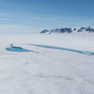
The scientists turned their attention to northern Ellesmere Island, where a seismological station has been taking readings since 1990. It is located in a region that is known by Indigenous Inuktitut peoples as Tuvaijuittuq or “last ice area;” it is where the last vestiges of multiple-year-old sea ice have been retreating over the last decades.
As the station monitors the Earth, it picks up the vibrations of waves crashing against the island. Normally, scientists filter this “noise” out to focus on the deeper Earth signals. But this time they turned their attention directly to the background noise itself.
They found definite patterns in the data. “In wintertime, the sensors pick up less noise because the expanded sea ice dampens the waves,” explained Chen, a PhD student in geophysical sciences. “But in the summer, the ice melts and the ocean waves get louder.”
In addition to the yearly cycles, the scientists saw a clear overall increase in noise over time. This correlates with satellite pictures showing less and less sea ice over the years, especially ice that has remained frozen for multiple years. Less ice means waves crash into the shore more often.
“This is a proof-of-concept paper,” said Sunyoung Park, assistant professor of geophysical sciences and co-author on the paper. “Next, we can start to look at the data at a finer scale, which we can’t do with satellites. How does sea ice change from night to day, or during short-term heat waves, or other weather events? We can also try to map sea-ice thickness or strength by combining data from multiple sensors.”
The scientists are planning to install more seismology sensors, in the Antarctic as well as the Arctic. For example, Chen is deploying sensors to see if data can be tracked for ice that’s floating rather than on land.
“This is just the tip of the iceberg, so to speak,” MacAyeal said. “These signals are telling us rich things about ice and climate interactions and climate change.
“It’s huge to have an independent way to see how climate change is modifying the Arctic.”
Citation: “Tracking Multiyear Sea-Ice Variation in the Arctic Ocean Over Decades With Microseism.” Chen, Park and MacAyeal, Geophysical Research Letters, Jan. 11, 2025.
Funding: National Science Foundation, Bremerhaven Sea-Ice Symposium of the International Glaciological Society, University of Chicago.